Key Activities
Geospatial Imagery Information
NGII produces a variety of national geospatial imagerythrough high-resolution aerial photograph technology
Utilization of Drones
NGII shares the principle of aerial photography to middle, high school and university students and its relevance to geospatial information through demonstrations of drone flight
NGII operates unmanned aerial vehicle (UAV) to quickly obtain images in case of disaster and provides the data to relevant organization for damage restoration
-
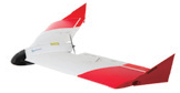
Fixed wing UAV
Dimensions: 1.2meters (width) x 42cm (lenght) / 1.2kg
Flying altitude / speed: 100~1,200meters / 50km/h
More stable to operate than rotarywing drones yet requiring sufficent landing space
-
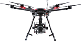
Rotary wing UAV
Dimensions: 1meter x 1meter x 45cm / 3.5kg
Flying altitude / speed: max.1,000meters / 40km/h
Fewer limitations on takeoff landing yet substantially affected by weather